
Diagnostic of the impact of fires on macro habitat in the PRNH SESC Pantanal from the point of view of multispectral data obtained by RPAS/drone
DOI:
https://doi.org/10.37002/biodiversidadebrasileira.v14i4.2570Keywords:
Wetlands , remote sensing, high resolution, temporal analysisAbstract
The year 2020 was impactful due to the high intensity of fires that occurred in the Pantanal. In this way, efforts were created in the most varied fields of knowledge to analyze and diagnose the causes and consequences in the
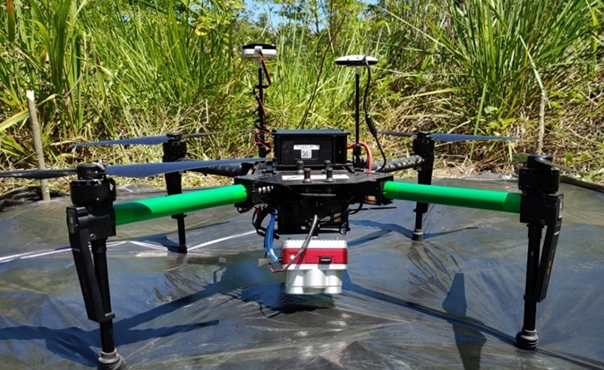
environment. Considering the innovation with the use of multispectral sensors integrated into RPAS, this work aimed to monitor and temporally map existing macro habitat in the PRNH SESC Pantanal, allowing the characterization of
vegetation coverage and the severity caused by the fires that occurred in 2020. Three areas with distinct macro habitat were mapped for the years 2019, 2020 and 2021, using the Micasense Altum multispectral camera and advanced processing methods. The Area 3 – Campina, had the highest level of severity in the impact of the fires, followed by Area 1 – Mata Seca with Tabocal with Campina and Area 2 – Mata Seca with Acuri. The most affected macro habitat were Tabocal and Campina, where with thermal data information was obtained on temperatures in degrees Celsius above 65ºC in the areas affected after the fire. Studies using calibrated data with high spatial and spectral resolution are fundamental for the complete radiography of natural environments, especially humid areas that are
highly sensitive. The results obtained allow better management of the reserve and effective results for state and federal environmental agencies regarding the
impacts of fires in the Pantanal biome, allowing subsidizing actions aimed at the conservation of Wetlands.
Downloads
References
Junk WJ et al. Brazilian wetlands: their definition, delineation, and classification forresearch, sustainable management, and protection. Aquatic Conservation: Marine and Freshwater Ecosystems. 2014; 24: 5-22. DOI: https://doi.org/10.1002/aqc.2386
Sanches LS et al. Seasonal Patterns of Evapotranspiration for a Vochysiadivergens Forest in the Brazilian Pantanal. Wetlands. 2011; 31:.1215-1225. DOI: https://doi.org/10.1007/s13157-011-0233-0
Ramsar. Information sheet for a new RAMSAR wetland in the Pantanal. 2003. Disponível em: <https://rsis.ramsar. org/RISapp/files/RISrep/BR1270RISformer_160210. pdf>;Acessoem: 23dejunho de 2020.
Libonati R, Dacamara C, Peres LF, De Carvalho LAS, Garcia LC. Rescue Brazil’s burning pantanal wetlands. Nature. 2020; 588: 217-219. https://doi.org/10.1038/ d41586-020-03464-1. DOI: https://doi.org/10.1038/d41586-020-03464-1
Marengo JA, Cunha AP, Cuartas LA, Deusdará KRL, Broedel E, Seluchi ME, Michelin CM, Baião CFP, Ângulo EC, Almeida EK. Kazmierczak, Mateus NPA, Silva RC, Bender F. Extreme drought in the brazilian pantanal in 2019–2020: characterization, causes, and impacts. Front. Water3, 2021; 13. DOI: https://doi.org/10.3389/frwa.2021.639204
Thielen D, Schuchmann KL, Ramoni-Perazzi P, Marquez M, Rojasn W, Quintero JI et al. Quo vadis Pantanal? Expected precipitation extremes and drought dynamics from changing sea surface temperature. PLoS One. 2020; 15: e0227437. DOI: https://doi.org/10.1371/journal.pone.0227437
Ministério do Meio Ambiente. Biodiversidade do Cerrado e Pantanal: áreas e ações prioritárias para conservação. Série Biodiversidade 17. MMA. Brasília: MMA, 2007. 540p.
Boon MA, Tesfamichael S. Wetland vegetation integrity assessment with low altitude multispectral UAV imagery. International Conference on Unmanned Aerial Vehicles in Geomatics. Anais... Bonn, Germany: 2017. DOI: https://doi.org/10.5194/isprs-archives-XLII-2-W6-55-2017
Doughty CL, Cavanaugh KC. Mapping coastal Wetland biomass from high resolution Unmanned Aerial Vehicle (UAV) imagery. Remote Sensing, 2019; 11(5): 540-576. DOI: https://doi.org/10.3390/rs11050540
Samiappan S et al. Mapping of invasive phragmites (common reed) in Gulf of Mexico coast wetlands using multispectral imagery and small unmanned aerial systems. International Journal of Remote Sensing, 2016; 00(00):1-22.
Nascente JC. Análise de dados orbitais e suborbitais no diagnóstico e mapeamento de áreas prioritárias para conservação no Corredor da Chapada dos Guimarães, Dissertação de Mestrado. Programa de Pós-Graduação em Ciências Florestais e Ambientais-UFMT, 2020, 136p.
Valles HEP, Nunes GM, Berlinck CN, Gonçalves LG, Ribeiro GHPDM. Use of remotely piloted aircraft system multispectral data to evaluate the effects of prescribed burnings on three macrohabitats of Pantanal, Brazil. Remote Sens. 2023; 15: 2934. https://doi.org/10.3390/ rs15112934 DOI: https://doi.org/10.3390/rs15112934
Antas PTZ. Plano de manejo da Reserva Particular do Patrimônio Natural SESC Pantanal. SESC, Departamento Nacional. Rio de Janeiro/RJ, ed. 2, 2011. 148p.
Hasenack H, Cordeiro JLP, Hofmann GS. O clima da RPPN SESC-Pantanal (Relatório final do projeto Conhecendo o Clima da RPPN SESC-Pantanal). Porto Alegre: Centro de Ecologia, UFRGS – Universidade Federal do Rio Grande do Sul, 2003. 31 p.
Dubs B. Observations on the differentiation of woodland and wet savanna habitats in the Pantanal of Mato Grosso, Brazil. In: Furley PA, Proctor J, Ratter JA (eds.). Nature and dynamics of forest-savanna boundaries. London: Chapman and Hall, 1992. 431-449.
Ratter JA, Pott A, Cunha CN, Haridasan M. Observations on wood vegetation types in the Pantanal and at Corumbá, Brazil. Notes Royal Botanical Garden of Edinburgh, 1988; 45: 503-525.
Hofmann GS. Relações entre a temperatura do ar e a estrutura de formações vegetais no norte do Pantanal de Mato Grosso, Instituto de Biociências-Programa de Pós-Graduação em Ecologia-UFRGS, Dissertação de Mestrado, 2008.
Lowe DG. Object recognition from local scale- invariant features. Proc. 7th International Conference on Computer Vision (ICCV’99) (Corfu, Greece).1999; 1150- 1157. doi:10.1109/ICCV.1999.790410 DOI: https://doi.org/10.1109/ICCV.1999.790410
Lowe DG. Distinctive image features from scale-invariant key points. International Journal of Computer Vision. 2004; 60(2): 91-110. doi:10.1023/ B:VISI.0000029664.99615.94. DOI: https://doi.org/10.1023/B:VISI.0000029664.99615.94
Szeliski R. Computer Vision: algorithms and Applications. London: Springer, 2010. 812 p. DOI: https://doi.org/10.1007/978-1-84882-935-0
Chuvieco E, Martin MP, Palacios-Orueta A. Assessment of different spectral indices in the red-near- infrared spectral domain for burned land discrimination. Remote Sensing of Environment, 2002; 112: 2381-2396. DOI: https://doi.org/10.1016/j.rse.2007.11.007
Bøgh E, Broge NH, Hasager CB, Jensen NO, Schelde K, Thomsen A. Airborne multi-spectral data for quantifying leaf area index, nitrogen concentration and photosynthetic efficiency in agriculture. Remote Sensing of Environment, 2002; 81(2-3): 179-193. DOI: https://doi.org/10.1016/S0034-4257(01)00342-X
QI J, Chehbouni A, Huete AR, Kerr YH, Sorooshian S. A modified soil adjusted vegetation index. Remote Sensing of Environment, 1994; 48: 119-126. DOI: https://doi.org/10.1016/0034-4257(94)90134-1
Rouse JW, Haas RH, Schell JA. Monitoring vegetation systems in the Great Plains with ERTS. In: ERTS-1 SYMPOSIUM, 3., 1973, Washington. Proceedings...Washington: NASA, 1974; 1: 309-317.
Roujean J-L., Breon, F-M. Estimating PAR Absorbed by Vegetation from Bi-Directional Reflectance Measurements. Remote Sensing of Environment, 1995; 51: 375-384. http://dx.doi.org/10.1016/0034-4257(94)00114-3 DOI: https://doi.org/10.1016/0034-4257(94)00114-3
Published
Issue
Section
License
Copyright (c) 2024 Os autores mantêm os direitos autorais de seus artigos sem restrições, concedendo ao editor direitos de publicação não exclusivos.

This work is licensed under a Creative Commons Attribution-NonCommercial-NoDerivatives 4.0 International License.
Os artigos estão licenciados sob uma licença Creative Commons Atribuição-NãoComercial-SemDerivações 4.0 Internacional (CC BY-NC-ND 4.0). O acesso é livre e gratuito para download e leitura, ou seja, é permitido copiar e redistribuir o material em qualquer mídia ou formato.